

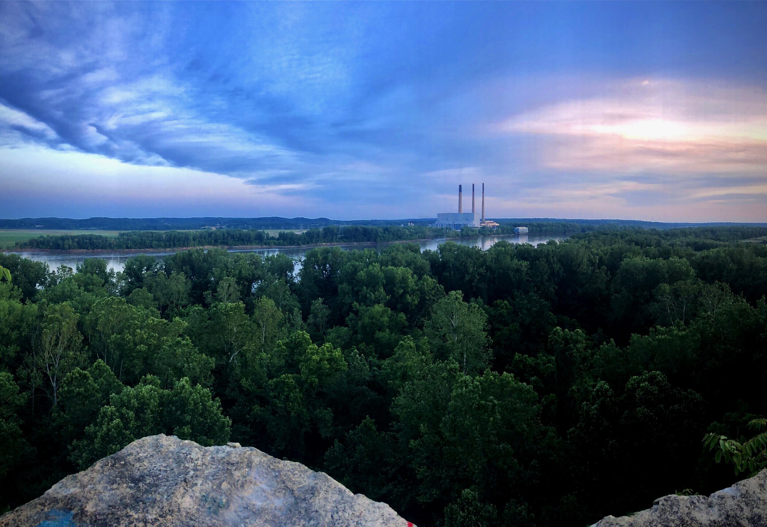
Checkout the trail maps and directions below and explore the Boone-Duden Area!

The Driving Tour and Hikes in the western St. Charles County feature historical points of interest and beautiful landscapes.
+ Daniel Cemetery Hike
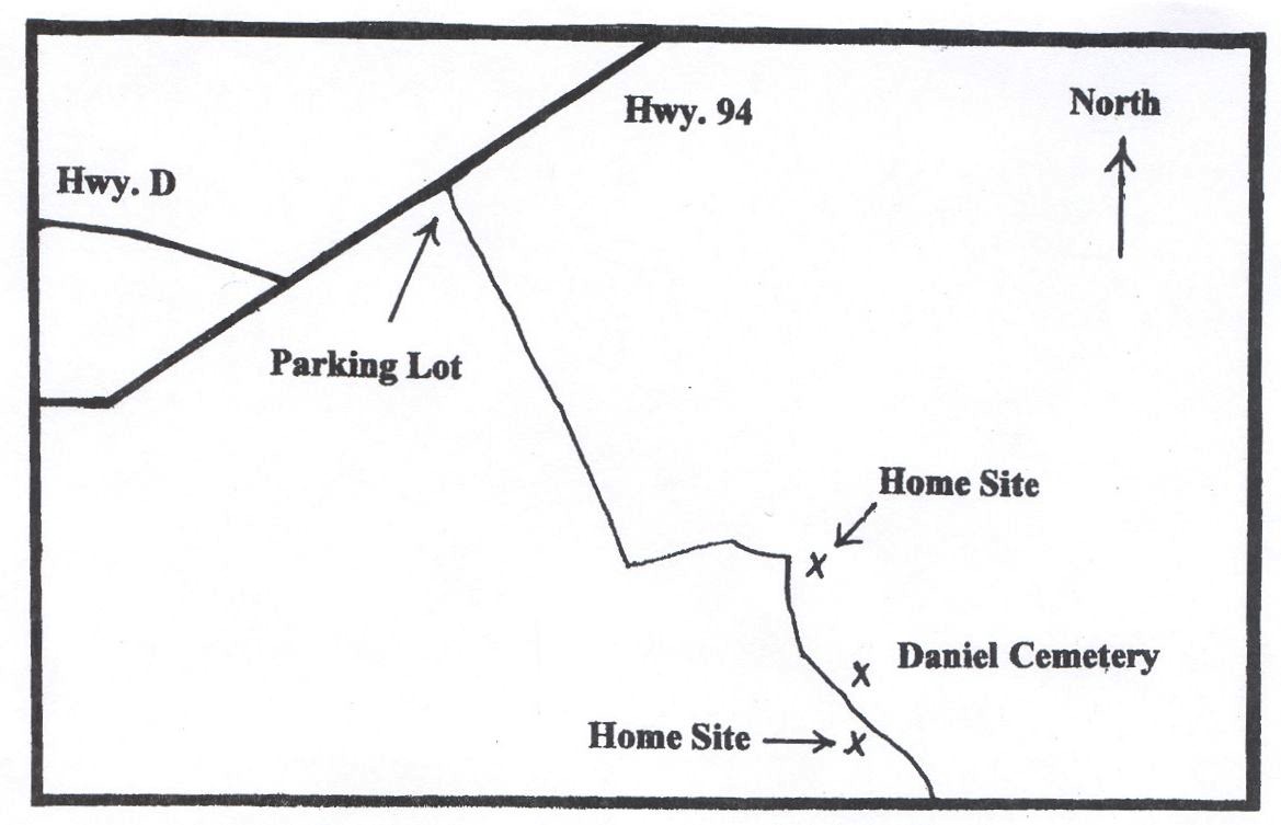
Last month the newsletter featured a hike to the Muschany Cemetery on Lost Valley Trail. This month the Daniel Cemetery in the northern part of our area is featured. This hike does involve GPS coordinates, but anyone with a compass and good sense of direction will have an enjoyable walk.
Directions:
- Park in the Missouri Conservation Department lot on the south side of the road, .35 miles east of the junction of Highways D and 94. The trail goes to the southeast; it is the old road that eventually ended at the ferry on the Missouri River. In .7 miles the road makes an obvious sharp turn to the left. In .15 miles the trail comes to a Y in the road; bear to the right. In another .15 miles the trail comes to another Y; again bear to the right. This trail is clearly marked, so you should have no trouble following it.
- Walk another .15 miles and you will arrive on the Daniel Cemetery on your left (N38.41.39.1, W90.41.34). Note the headstones in German. The earliest burial here was in 1874. According to records, several unmarked graves are also here.
- If you walk only about 200 feet further down the trail, you can attempt to locate the site of the original Daniel home on the right of the trail (N38.41.35.2, W90.41.32.3). You should find a large depression marking a cellar, the top few feet of the well, and piles of rubble. This farm was owned by M. Daniels (who is buried in the cemetery) from at least 1875 until 1910; Catherine Lauer owned it in 1940.
- If you want to do more exploring, on your way back to the trailhead, stop at that Y .15 miles from the cemetery. This time turn to the right (off the trail) and walk about 130 feet (N38.41.45.8, W90.41.33.9). You will be standing on a farm owned by Richard Rosenthal from at least 1875 until 1910; Kenneth Bitting owned it in 1940. A few yards to the right you should find a farm pond, the top few feet of the well, and daffodils (in the spring). In the first ravine to the left you should find the farm's trash heap. If you look carefully, a lot of interesting artifacts can be observed.
The total distance covered in this hike is about 2 ½ miles. Hope you have a great walk!
+ Heritage Driving Tour
In 2005, the Boone-Duden Historical Society decided to undertake the task of erecting a historical sign in every community, both large and small, both remembered and forgotten, in southern St. Charles County and eastern Warren County, the area encompassed by the Society's charter. The effort progressed slowly over the years, with signs erected for Dortmund, Nona, La Charrete, Marthasville, and the original site of Dutzow. In 2012, two more signs were placed for North Washington and New Melle. A sign was placed at Schluersburg and in 2020 one placed in Augusta. Now the society is ready to place two more signs, both double-sided, for Hamburg, Lower Hamburg, Howell, and Toonerville. As of January 2022, the Heritage Sign Project is nearly complete.
The purpose of these signs is to ensure that the histories of these small communities are not forgotten. Each 4' by 4' sign contains a chronological overview of the town's past, and some signs include photographs or maps. Each maintenance-free sign is green with routed letters and mounted to white decorative posts.
Included in this issue is a Heritage Sign Driving Tour with a map and very specific directions to the locations of each of the current signs and the future locations of the Hamburg/Lower Hamburg and Howell/Toonerville signs. If you live in the area, why not spend a couple of hours driving the tour and reading the signs? You may learn something new!
This tour does not include information about the communities; that is the purpose of the signs! However, if you wish to learn more about these towns, including the ones that no longer exist, you may wish to obtain any of the following books from the St. Charles County library:
- Dutzow: A Place of Dreams by Urban Reuther
- The Historical Center of Duden Country: Dutzow, Missouri by Jerry Holtmeyer
- La Charrette:Village Gateway to the American West by Lowell Schake
- Emmaus Homes: 100 Years, 1893-1993 by Ralph Gregory
- The Rape of Howell and Hamburg by Donald K. Muschany
- A Dream Left High and Dry: the Town of Dortmund by Anita Mallinckrodt
These websites may also prove helpful:
thetntstory.org and boone-duden.com/history/map.
Directions:
Begin the tour at the Kamphoefner House, the Boone-Duden Historical Society headquarters, in New Melle, just south of the stoplight at Highway D and Mill Street. The sign is at the front of the house.
Take Highway D west for 4.7 miles until it joins Highway T. Turn left and proceed 3.0 miles where Highway D turns to the right, leaving Highway T. Stay on Highway D for 6.1 miles (when you enter Marthasville, Highway D becomes Main Street and eventually One Street). Just after crossing the Katy Trail, you will come to Wessel Park. Turn left into the park to read the double-sided sign for La Charrette and Marthasville.
Continue on Highway D for .1 miles until the stop sign at Highway 94. Turn left on Highway 94. As you approach the turn for Dutzow, the spire of St. Vincent de Paul's Catholic Church is visible on the ridge in the distance. Turn left to go to Dutzow. At the junction of Highways TT and Highway 94, you will have driven 4.1 miles since joining Highway 94. Take Highway TT .3 miles north until you arrive at the Marthasville fire station on the left. The double-sided sign for the Lake Creek Valley Area and North Washington is in the station parking lot.
Return to the intersection of Highways TT and 94, .3 miles. Turn left on Highway 94 and proceed 1.1 miles to St. Vincent de Paul's Catholic Church. There is a parking area next to the double-sided sign for Dutzow and St. Vincent de Paul's Catholic Church.
Continue to the east on Highway 94. After 2.1 miles, turn right on Emke Road, and then drive .8 miles to Augusta Bottom Road. Turn left on that road and drive .9 miles. On your right will be the sign for Nona. There is no parking area here, but traffic is light, so you probably will have time to read the sign from your car.
Continue to the east on Augusta Bottom Road for 2.2 miles. Immediately after turning left on Schell Road, you will see the sign for Dortmund on your right. There is no parking area, but you should have time to read the sign from your car.
Drive north on Schell Road for 1.2 miles to Highway 94 where you will come to a stop sign. This stop sign is just after the crest of a hill, so be prepared to stop as you approach the crest. Turn right on Highway 94 and drive 2.2 miles to Schluersburg Road, where you will turn left, and then proceed 4.4 miles to Schluersburg, where you will find the sign for that town on your left, in front of the Bethany U. C. C. Church.
Continue on Schluersburg Road for 1.4 miles until you come to Highway F. Turn right on Highway F for 4.0 miles until arriving at Highway 94. Turn left and drive 2.9 miles to a Missouri Department of Conservation parking lot on your left. The double-sided sign for Hamburg and Lower Hamburg will be located in this lot. Use the sign text later in this issue to learn about these communities.
Turn left from the parking area and continue on Highway 94. Howell and Toonerville. Use the sign text later in this issue to learn about these communities.
+ Hutchings Cemetery Hike
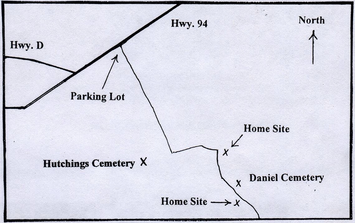 The Hutchings Cemetery is in the northern part of the TNT. This hike does involve GPS coordinates, but anyone with a compass and good sense of direction will have an enjoyable walk.
Directions:
Park in the Missouri Conservation Department lot on the south side of the road, .35 miles east of the junction of Highways D and 94. The trail goes to the southeast; it is the old road that eventually ended at the ferry on the Missouri River. As you follow the trail, in .5 miles, you will approach the crest of a hill. At this point you must leave the old road and walk toward the south-southwest. After walking .33 miles, you will approach the tree line. The cemetery is about one hundred feet into the trees (699736 4285452). It is clearly visible from the tree line.
This cemetery contains approximately thirty graves with unmarked stones, and two with marked headstones, those of Christopher and Rachel Hutchings, both of whom died before the Civil War. According to records, a third marked headstone was noted here in the 1930's but was missing by the 1980's. It also marked a pre-Civil War burial. The enclosure consisting of four stone walls no doubt designates someone's grave, but no one knows for certain. The same is true for the smaller stone structure a few yards away. Next to this second, smaller stone structure is a grave marked with two very large flat stones. The grave, approximately seven feet long, is thought to be the grave of William Pitman. It is clear from the number of graves that this cemetery was a major burying ground for this area in the nineteenth century.
This hike is easily combined with the Daniel Cemetery Hike.
+ Lower Hamburg Road Hike
This hike will explore the road that connected the Marthasville Road (Highway 94) with Lower Hamburg, the location of the Hamburg depot on the Missouri-Kansas-Texas Railroad (Katy Trail) and a few other structures. The entire hike is about 2 ½ miles round trip.
Directions:
Pull off Highway 94 onto a shoulder of the road next to a metal gate and three large rocks (697146 4283384). This small parking area is 2.5 miles from the intersection of Highways 94 and D, and 3.5 miles from the intersection of Highways 94 and DD. Approximately fifty feet northeast of the three large rocks is the original roadbed. Along this roadbed, less than one hundred yards from Highway 94, is the location of the Hamburg School; no traces remain.
The trail begins, not on the old roadbed, but next to the metal gate; the worn path is obvious. Walk .12 miles down the trail; you will come to an abandoned railroad bed. The railroad cut on your left was constructed in 1940-1941. If you want to take the time, you can find the old road bed, still clearly visible, at the top of the hill, to the north. You can also find the remains of the Sudbrock home, including the intact front steps. Daffodils and other non-native flowers bloom in the springtime. Another old home site, that owned by Georgia Mailloux, is situated east of the Sudbrock home, just across the railroad cut.
Continue walking down the trail. When you reach the area of 697423 4282936, you will notice an old roadbed angling down the ridge on your left, toward the trail you are on. This is the original roadbed; from the point where it reaches the trail you are walking on, you will be on the old roadbed.
Continue walking; you are now walking on the original road. When you are .3 miles from the trailhead, stop and look toward the bottom of the ravine on your right. You will see an unusual concrete structure about twenty feet high. This is the spillway of an unfinished dam project from the 1930’s. Theodore Yahn, a local resident, decided to organize a private boating club and started the project, planning to dam a small stream that ran to the Missouri River. The project was abandoned, but the strange concrete structure in the middle of the woods remains!

As you continue walking down the trail, you will eventually near an old roadbed coming in from your right. Just a short distance down this road, you can find the Hamburg dump (697551 4282761). In 1905 a road was constructed that connected Hamburg to the Lower Hamburg Road. Hamburg residents began to dump their trash where the road crosses a ravine. Be sure to climb down into the creek bed and look at the beautiful stone arch.
The Heck-Roth Cemetery is .55 miles from the trailhead (697802 4282803). Only four graves currently have marked headstones, although records show that in previous years several other Roth graves had marked stones. Of special interest is the grave of Philip Heck, who was a regimental musician during the Civil War.
Only about 100 feet down the trail, on the same side of the road as the cemetery, is the cellar of a house owned by John and Susie Beatty in 1940. Note the stonework in the walls and what the remains of a concrete front porch. A few yards from the back of the ruins stands a hive-shaped well cover. If you look over the edge of the ravine about fifty feet behind the ruins, you will see several broken bottles, pieces of metal, and other trash. Who knows what treasure you might find here? Across the trail, between the cemetery and the home location, you can look for the remains of the Adolf and Rose Daniel house.
- Continue walking down the trail. When you have walked .85 miles from the trailhead, you will arrive at the Katy Trail. It is in this area where the Hamburg train depot stood. Turn left/northeast and continue walking, now on the Katy Trail. Walk .54 miles. Leave the trail on the left and walk 150 feet to the north to find the Pitman Cemetery (698843 4283399). As you walk toward the cemetery, you will notice the remains of a stone foundation on your left. This is what is left of a home owned by Charles Siedentop from at least 1875 until 1905, and by Agnes Koladzey in 1940. If you look carefully, you may also find the foundation of a second smaller building still outlined on the ground and the stone-lined cistern (the cistern has been covered over with large branches to prevent someone from falling in). Note the periwinkle, a non-native plant, that covers the ground in this area.
This cemetery is located in an area once known as Wards Hollow. Once the site of several graves, it now contains only the marker for Richard Pitman, who died in 1842. Pitman settled in St. Charles County in 1811. According to an old account of the cemetery, the farmer who owned the land simply removed the headstones in order to have more land to plow. A descendant of Richard Pitman later convinced the farmer to return Pitman’s marker to its original location.
Enjoy your hike!
+ McRoberts & Scott Cemeteries Hike
The McRoberts and Scott Cemeteries provide another opportunity for a hiker to combine walking with local history. This hike is approximately 4 ½ miles roundtrip and involves some hills, so be prepared for some good exercise. The destination is an area where a small African-American community was located, apparently for several decades. According to an article in the St. Louis Globe-Democrat on February 25, 1941, forty-two slaves are buried in these two cemeteries. The cemeteries contain no marked headstones, but several unmarked stones, many of which were discovered buried and reset within the last few years.
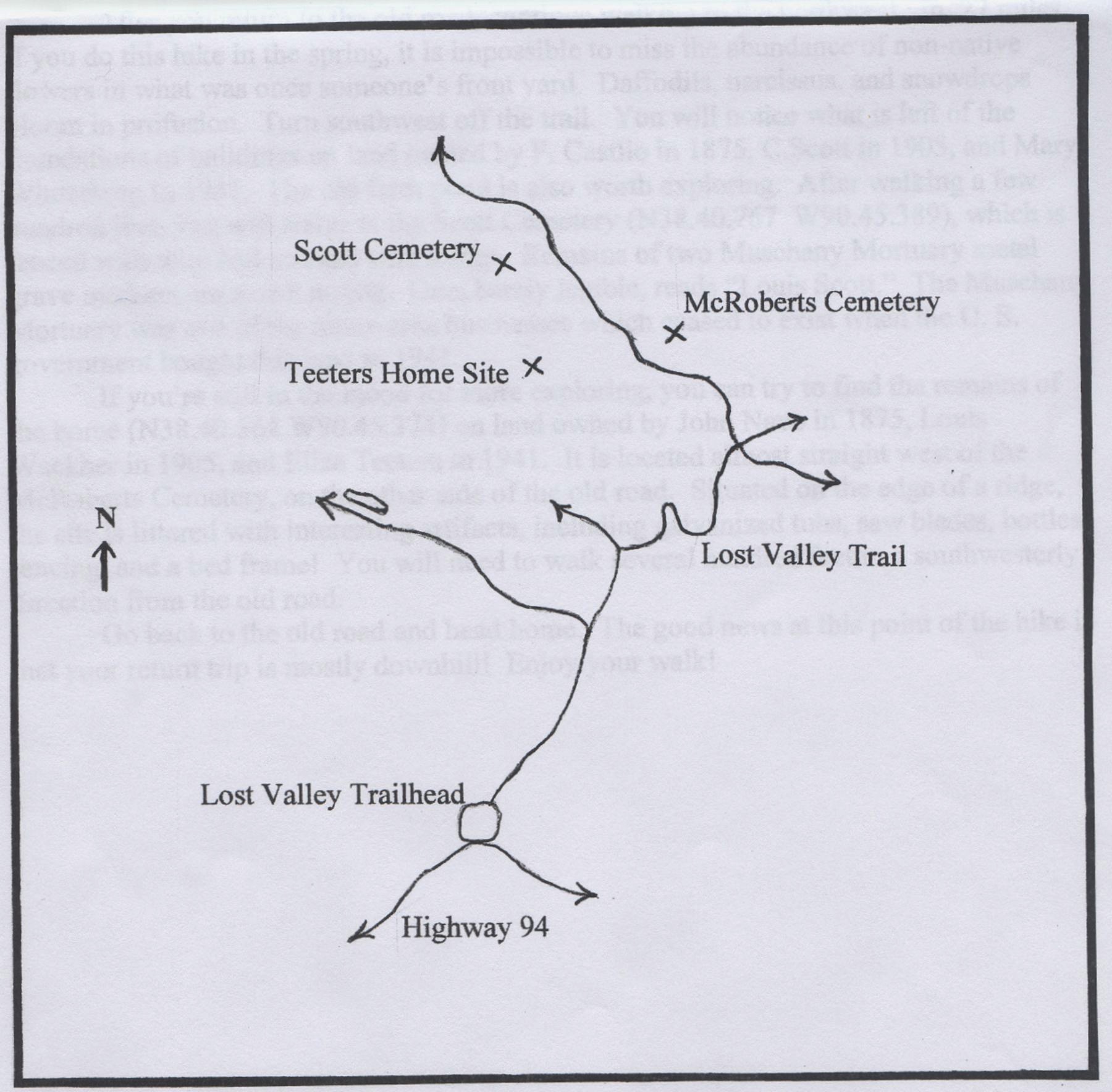
Directions:
- Park in the Lost Valley Trail parking lot, which is located on the north side of Highway 94, just a ways down the road from the intersection of Highways DD and 94.
- Follow the trail northeast. As you walk on this trail, you will be following Muschany Hollow Road, that ran from the Marthasville Road (Highway 94) to the town of Howell, one of the villages removed by the U. S. government in 1941. The trail parallels Little Femme Osage Creek.
- Continue walking to the northeast; do not follow the trail when it turns to the northwest. From this point you will be following the Lost Valley Trail in a counterclockwise direction.
- When you have walked .7 miles from the trailhead, the Lost Valley Trail will turn to the east. You immediately descend into a small creek which may have a few inches of water. Walk .37 miles. The trail curves around a couple of ravines and eventually crosses an old road (695839 4282730). As of this writing (Nov. 2010), a 4”x4” metal trail sign is posted. It reads “TRAIL” and points BACK down trail on which you have been walking.
- Turn left onto the old road, which climbs a lengthy hill. In .7 miles turn off the trail to the east; within a few hundred feet you will see the McRoberts Cemetery (695620 4283351). It is fenced with wire and marked with a historical society sign. Records from 1941 indicate thirty graves. Several unmarked depressions are obvious. As you walk back to the old road, you will pass by what remains of the home on land owned by John Navo in 1875, Henderson McRoberts in 1905, and John Hamm in 1940. Look carefully and you may find the concrete cover to the well with the words “Walter Jesse” etched on it. This area is covered with daffodils in the springtime.
- After you return to the old road, continue walking to the northwest. In .27 miles on the left, if you do this hike in the spring, it is impossible to miss the abundance of non-native flowers in what was once someone's front yard. Daffodils, narcissus, and snowdrops bloom in profusion. Turn southwest off the trail. You will notice what is left of the foundations of buildings on land owned by F. Castlio in 1875, C. Scott in 1905, and Mary Winterberg in 1940. The old farm pond is also worth exploring.
- After walking a few hundred feet, you will arrive at the Scott Cemetery (695154 4283593), which is fenced with wire and marked with a sign. Remains of two Muschany Mortuary metal grave markers are worth noting. One, barely legible, reads “Louis Scott.” The Muschany Mortuary was one of the many area businesses which ceased to exist when the U. S. government gained control of this land in 1941.
- If you're still in the mood for more exploring, you can try to find the remains of the home (695185 4283219) on land owned by John Navo in 1875, Louis Wackher in 1905, and Eliza Teeters in 1940. It is located almost straight west of the McRoberts Cemetery, on the other side of the old road. Situated on the edge of a ridge, the site is littered with interesting artifacts, including galvanized tubs, saw blades, bottles, fencing, and a bed frame! You will need to walk several hundred feet in a southwesterly direction from the old road.
- Go back to the old road and head home. The good news at this point of the hike is that your return trip is mostly downhill!
Enjoy your walk!
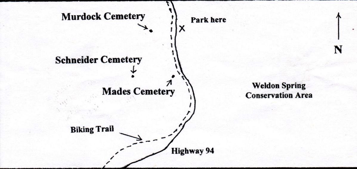
+ Murdock, Mades, Schneider Map
This hike explores the area immediately to the north of Hamburg, a village removed by the U. S. government in 1940 in order to secure the area to build a munitions factory. The Mades Cemetery is located on what would have been the edge of town, the Murdock Cemetery just out of town, and the Schneider Cemetery on a farm within sight of Hamburg. While the Mades and Murdock Cemeteries are easy to find, a compass is very helpful in locating the Schneider Cemetery.
Directions:
- Pull off Highway 94 onto a shoulder of the road next to a metal gate and three large rocks (695839 4282730). This small parking area is 2.5 miles from the intersection of Highways 94 and D, and 3.5 miles from the intersection of Highways 94 and DD. Carefully cross Highway 94 to the west-northwest. Walk through the opening in the old fence and climb down the short hill to the biking trail. Walk about fifty feet north on the trail and face west. As you look about one quarter mile in the distance, you will see a group of very tall cedar trees; this is the Murdock Cemetery (696813 4283337). The distance from Highway 94 to the cemetery is two-tenths of one mile.
- When the U. S. government purchased the 18,000 acres it felt it needed to secure its plant, it created a problem for itself which it never really solved. What should be done with the two dozen cemeteries on this land? Newspaper articles from the period indicate obvious confusion. There was talk of disinterring all of the 700 bodies at government expense and then reburying them in a tract of land purchased by the government. This never happened. Then the suggestion was made to remove bodies only if relatives requested reburial. This plan was also apparently not fully implemented. The Murdock Cemetery, however, shows evidence of several disinterments. Old cemetery records indicate that John and Louisa Murdock, Martha S. Snyder, and Edward Harris were buried in the cemetery, and their gravestones were still present in 1940. Later records indicate that these remains were all removed to Oak Grove Cemetery in St. Charles in 1941. Was this the beginning of a mass removal of all area remains, or were these the only graves whose removal was requested by relatives? This is one of the only three cemeteries in all of the area's two dozen cemeteries that indicate bodies were removed in 1941. If you look carefully, you may find the bases for the missing headstones. Three are visible, one obviously a larger base intended for a double headstone (the Murdocks). It is worth noting that the Murdocks died within ten days of each other in 1877 and were the first burials here, on the farm they owned; John Murdock was the son of a Revolutionary War veteran.
- To find the Schneider Cemetery (696707 4282968), first stand in the Murdock Cemetery gate, facing east. Walk around the cemetery to the right (south). Turn at the corner and walk west-southwest; the cemetery is now on your right. Notice the ridge ahead of you, rising to your left. Continue west-southwest and then gradually turn southwest to climb the spine of the ridge. Walk to the top of the hill; at this point you have walked just over one-tenth mile from the Murdock Cemetery. The spine of the ridge now heads south-southwest. Walk to the end of the ridge's spine and stop at its highest point; you are now about .17 miles from the Murdock Cemetery and 150 yards from the Schneider Cemetery. Walk down the hill to the south, perhaps just a bit east of due south. The Schneider Cemetery is fenced and has a sign. The farm belonging to the Schneiders had been in their family for about one hundred years when they sold it to the government before World War II. No traces of the home remain except for a large depression about one hundred yards south from the cemetery; in the spring this hole is surrounded by beautiful daffodils. It apparently marks the location of the farm's barn.
- This cemetery is the other that evidences the removal of bodies, and the bases for the absent headstones are clearly visible. Jacob and Louise Schneider died exactly one month apart in 1869. Records indicate that sometime before 1941 their remains were reinterred in St. John's Cemetery in Cottleville. Of the 700 bodies buried in the 24 cemeteries, it appears that fewer than fifteen were reburied. The rest were left in the original family and church cemeteries.
- The final cemetery on this brief hike is the Mades Cemetery (697128 4282899). It is almost due east of the Schneider Cemetery, so take the appropriate reading on your compass and begin the short trek of almost exactly one-quarter mile. You will walk down the ridge the Schneider Cemetery is on, up and around the base of a hill, and up another hill. As you approach this final hill, you may notice the old roadbed which ran from Highway 94 past the Schneider farm and on over the next ridge, towards the village of Howell. This cemetery is hard to miss since it is marked by a very large cedar tree, is surrounded by its original fence, and is within a stone's throw of Highway 94. The buildings of the Mades farm sat adjacent to the cemetery.
- The rest of the hike is just a brief walk up the biking trail to where your car is parked. Your total walk was only about one mile, but you explored some of the farms first settled by immigrants to the area.
+ Muschany Cemetery Hike
If you have an hour or so, are in the mood for some exercise, and desire to experience some local history, you may want to attempt to find the old Muschany burying ground. The cemetery can easily be found with just a good sense of direction and a little effort!
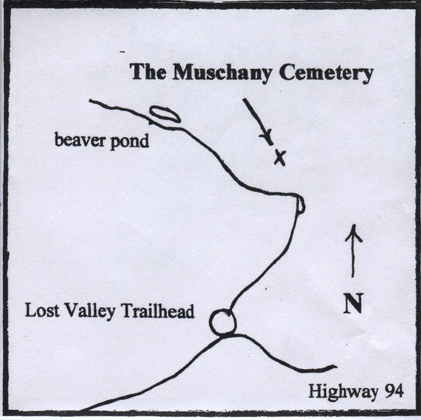
Directions:
- Park in the Lost Valley Trail parking lot, which is located on the north side of Highway 94 just a ways down the road from the intersection of Highways DD and 94. Follow the trail northeast. As you walk on this trail, you will be following the Muschany Hollow Road, that ran from the Marthasville Road (Highway 94) to the town of Howell, one of the villages removed by the U. S. government in 1941. The trail parallels Little Femme Osage Creek.
- After approximately .45 mile, the road turns to the northwest. In 270 feet, the trail crosses a very narrow stream. Walk 30 feet beyond the stream and look to the right. You will see a hill. This is the site of the farmhouse where several generations of the Muschany family lived.
- Walk north, up the hill, less than 100 yards. As you reach the top of the hill, look to the east and, you will see the cemetery (695358 4282424). It is fenced with wire and marked with a sign.
- Only members of the Muschany family are buried here. The first two burials were only eight days apart in 1876 and were those of two very young children. One can only imagine the grief that was expressed in this little cemetery at that time. Another grave worth noting is that of John Muschany, who was a Civil War veteran. Also be sure to look at the peculiarly positioned headstone of Catharine Muschany; it faces south, not east, the traditional headstone direction.
- As you leave the cemetery, walk several yards to the west of the cemetery and look for the pile of rubble, all that is left of the Muschany home. If you look carefully, you may find the remains of their cistern; the top few feet of stonework are exposed. In the springtime, this area is covered with daffodils, planted long, long ago by family members.